Drones 'Game Changing' for Aramco, Shell, Chevron and bp
The first known unmanned aerial vehicle (UAV), or drone, was created in 1916 and can today be purchased by everyday people for less than US$50.
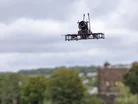
Now, among other uses, drones are used by companies across the energy industry to make operations more efficient, sustainable and safe.
“The advent of drones in the oil and gas industry is a game-changer,” says Khalid Y. Al-Qahtani, Senior Vice President of Engineering Services at Saudi Aramco.
How drones can support infrastructure inspections
Drones are used extensively in the energy industry to inspect critical infrastructure such as power lines and grids.
Equipped with HD cameras, they can help to quickly identify structural weakness, corrosion or potential hazards on high-voltage power lines.
Wind turbines can reach as tall as 280 metres and can be inspected for damage using drones without putting human inspectors at risk.
Shell started investigating the use of drones around 2010 and has integrated them into its inspection processes.
The company uses automated drone flights to monitor tank farms at the Energy and Chemicals Park Rhineland.
Drones can inspect the roofs of tanks without someone being physically present on site.
"Shell is highly innovative in tank roof inspections with the deployment of the automated drone solution,” explains Thomas Klein, Digital Innovation Lead at Shell.
“This technology can also be used for many other monitoring tasks that make these operations safer and more efficient."
Machine learning and AI can then be used to identify abnormalities and alert when repairs may be needed.
Drone surveys of solar farms can reduce inspection costs by up to 50% alongside increasing efficiency and improving maintenance operations.
They can also be used to inspect oil and gas facilities, detecting potential issues in a fraction of the time required by traditional methods.
Chevron made history in May 2024 as the first company permitted by the Federal Aviation Administration (FAA) to use uncrewed aircraft systems (UAS) in airspace shared by crewed aircraft to monitor its network of pipelines.
As they use less fuel than traditional methods, the UAS is also a lower carbon emitting tool.
Enhancing safety with drones
Using drones in these ways for inspections prevents human inspectors from being potentially unnecessarily exposed to hazards such as heights or dangerous fumes.
Drones can also reduce the need for transport to offshore facilities which can be dangerous.
In the oil and gas industry, drone inspections can lead to efficiency gains of up to 33% and a 50% reduction in inspection costs alongside minimising risks to personnel.
The detailed imaging provided by drone cameras can include thermal sensors that detect risks missed by human eyes.
This also allows for more regular monitoring so safety risks can be identified and addressed earlier.
In the event of a disaster, drones can quickly survey areas without endangering human responders and detect and monitor oil spills or gas leaks rapidly.
Aramco has been expanding the use of drones in its facilities since 2015 and is using ultrasonic testing drones to detect flaws, defects or corrosion that may affect the safety of industrial assets and infrastructure.
Khalid explains: “Deploying industry-leading robotics and drone applications across Aramco’s business is driving safer, cost-effective, and more efficient practices.”
Drones for data collection and analysis in energy
Drones are also powerful tools for gathering and analysing data.
They can create high-resolution maps and timelines of energy infrastructure through various sensors.
- LiDAR (light detection and ranging) for topographical maps
- Anemometers to measure wind
- Pyranometers to measure solar irradiance
- Multispectral and hyperspectral sensors to capture data across multiple electromagnetic wavelengths
- Thermal imaging cameras to identify heat signatures
Sending a drone to capture imagery can produce millions of data points which can be timely for humans to sort through.
Advanced systems can use AI and machine learning to enhance performance and make operations more efficient.
Digital twins using drone data
LiDAR scanning can be used to create digital twins of energy infrastructure sites.
This can improve the speed and accuracy of data collection, particularly during major equipment changes.
bp has created digital twins of its production systems around the world using APEX and Microsoft Azure.
“Modularity is at the heart of bp’s digital approach to drive an integrated set of world-class customer experiences, reduce the time to value for new products, and enable bp to create new businesses,” says Abeth Go, Vice President for Data and Analytic Platforms at bp.

“We need to be able to mobilise very swiftly, especially when we're entering new markets. It's important that we have a modular operating model so that we can bring multidisciplinary teams together in a shared ecosystem of data assets and data products that spans the organisation.”
bp’s Data Hub is its core data ecosystem that integrates the entire data value chain and contains digital twins.
Make sure you check out the latest edition of Energy Digital Magazine and also sign up to our global conference series - Sustainability LIVE 2024
Energy Digital is a BizClik brand.